Geotechnical Characterization and Mapping of Kathmandu Valley
Abstract:
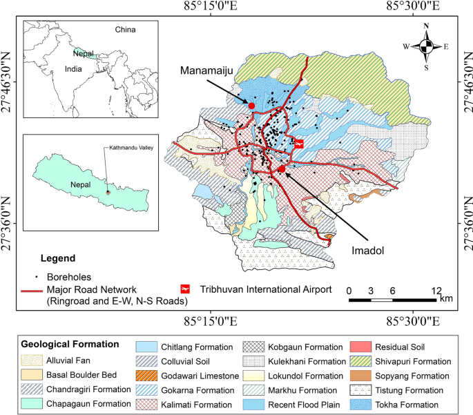
Kathmandu Valley, a rapidly urbanizing region of Nepal with a history of catastrophic earthquakes, is primarily underlain by lacustrine and fluvial-origin deposits. The valley’s subsoils are highly susceptible to seismic amplification and liquefaction, necessitating a comprehensive geotechnical characterization. This ongoing study aims to address the gaps in understanding the valley’s subsoils by characterizing their geotechnical properties, 3D subsurface lithology, and stratigraphy. The research involves analyzing data from over borehole reports, conducting geotechnical investigations at piloting borehole locations, and performing standard penetration tests (SPT-N) alongside laboratory tests. Advanced tools, including Rockworks 3D modeling and GIS mapping, are being employed to visualize lithology and the spatial variation of soil properties.
Preliminary results highlight the depth-wise and spatial variability of critical geotechnical parameters, including grain size distribution, dry unit weight, plasticity indices, shear strength, and shear wave velocity. Correlations between these properties are being developed, and geotechnical maps are under preparation to assist in urban planning, risk assessment, and foundation design. These efforts are expected to provide valuable insights for enhancing construction practices and earthquake resilience in the Kathmandu Valley.
Status:
Ongoing
Team:
Mandip Subedi, Keshab Sharma, Indra Prasad Acharya, Rajan KC, Netra Prakash Bhandary